
Hiking holidays in Merano
Merano is a perfect starting point for hiking tours in western South Tyrol because of its location at the end of the Vinschgau, Passeier Valley, Schnalstal and Ultental.
In the vicinity of Merano one can find hiking paths of all levels of difficulty: beginning from easy hikes along one of the Waalwege in the Vinschgau, Passeier valley or around Merano to demanding hikes on one of the mountain tops which raise over more than 3,000 m within the Ötztaler Alps.
A very popular hike is the Meraner Höhenweg in the nature preserve Texelgruppe. It leads through the Schnalstal, Pfossental, Pfelderer Valley and Passeier Valley around the Texelgruppe and it takes several days to complete it.
The ideal time for hiking tours within the Meranerland is late summer and autumn. Take advantage of the special location of Merano for hiking holidays and enjoy the quiet and the breathtaking panorama of the alps.
Survey map of the Meranerland and the Vinschgau

Hiking areas around Merano
Passeier Valley: Texelgruppe and Sarntaler Alps
The Passeier Valley runs from Merano in a northward direction and is situated between the Sarntaler Alps and the Texelgruppe, which is part of the Ötztaler Alps.
The Passeier Valley and the mountain pass over the Jaufenpaß, which branches off at St. Leonhard in Passeier, leads also to the southern part of the Stubaier Alps.
Vinschgau: Ortler Alps and Ötztaler Alps
The Vinschgau runs from Merano in a westward direction. Via the Vinschgau and its side valleys, one can reach the Ortler Alps (Martelltal, Trafoiertal, Suldental and Münstertal) and the parts of the Ötztaler Alps, which are located in South Tyrol (Schnalstal, Matscher Valley, Planeiltal and Langtauferertal).
The Sesvennagruppe is located west of the Obervinschgau, which is the part of the Vinschgau between Reschenpaß and Mals. However the distance to get there is then already about 60 - 80 km.
Ultental
The Ultental is south of the Marteller Crest of the Ortler Alps and runs parallel to the Vinschgau, which is north of it.
The Nonsberge, which are south of Merano, are also worth to mention. Although it doesn't have the impressive mountain tops like the Ortler Alps or the Ötztaler Alps, it is an insider's tip for its quiet and pleasant hiking paths. One can get there either via the Ultental and the Marauntal, which is a side valley of the Ultental, or from Lana via the Gampental and the Gampenjoch.
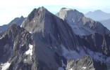
- Left: The Grafspitze (3,147 m) and the Hohe Weisse (3,278 m) are two striking mountain tops within the Texelgruppe near Merano.
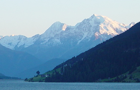
- Center: View from the Reschensee in the Vinschgau to the Ortler (3,905 m), which is the highest mountain top of the Ortler Alps. On the left side right behind the Ortler one can see the Königsspitze (3,851 m).
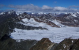
- Right: View from the Hohe Wilde (3,480 m) to the Gurgler Ferner, one of the many glaciers within the Ötztaler Alps.