
Hiking along the Meraner Höhenweg
Meraner Höhenweg
The Meraner Höhenweg is a beautiful round trip trail, which will take about 4-6 days to walk. The hike will lead around the Texelgroup in a constant height of about 1,400 m and is marked with the trail number 24.
But twice the hike will lead you also into higher regions. In the southern part, at the Hochganghaus, the Meraner Höhenweg will reach up to 1,839 m. And the heighest point will be reached in the northern part: the Eisjöchl at impressive 2,895 m.
The Meraner Höhenweg was opened as recently as 1985 and it is said that it is incomparable within the alps.
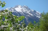
- Links: The Tschigat (2,998 m) within the nature preserve Texelgruppe.
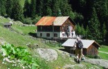
- Mitte: The mountain hut Nasereit (former Nassereithütte; 1,523m) on the Meraner Höhenweg was reopened in 2014 and is again available for accommodation
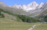
- Rechts: View into the Pfossental valley and the climb to to the Eisjöchl (2,895 m) and the Hohen Weisse (3,278 m) in the background.
Along the way, hikers can find stops for a bite to eat in regular intervals. There you will find also accommodation possibilities as well as shelter from rain and thunderstorms. It is therefore possible to complete the route just with light provisions and without a sleeping bag.
If you take at least an extra day, you can visit the higher located alpine lakes (Spronser Seen) and mountain tops.
The Meraner Höhenweg is an absolute highlight for every hiker because one can enjoy the beauty of the national park Texelgroup to the full.
Highlights of the Meraner Höhenweg
During the hike along the Meraner Höhenweg there is a wonderful view from the Passeier valley in the northward direction to the Jaufenpass and in the eastward direction to the Sarntaler Alpen. When you have reached Christl the direction of the valley changes to north west and uncovers a view to the foothills of the Stubaier Alpen and the main part of the Ötztaler Alpen.
Pfelders has been a solitary, isolated mountain village, which did not even have a church. In past decades Pfelders developed into the only skiing area of the Texelgruppe. However it has preserved its mountainous village character despite of the hotels, accommodations and shops. Witnesses are the mountain farmers in and around the village.
The Pfossen valley, a valley with the Similaun in its background, is the heart of the national park, because of its rich flora and fauna. In july and august a wide variety of alpine flowers blossom and the hike through this "heaven" could be truly called "path of the butterflies and wild cherries".
The Sonnenberg, which is situated in the Vinschgau is a typical example of a traditional south tyrolian mountain farming landscape. Not only in past decades access roads were built and cable cars developed for the supply of materials, thus enabling families to manage their farms more easily.
The Tschigatkamm ist the southernmost point of the Ötztaler Alpen. This huge mountain crest shields Merano against northern winds and is responsible for the mild climate with a blooming valley where fruits, wine and other mediterranian plants grow.